
 Portsmouth, Virginia
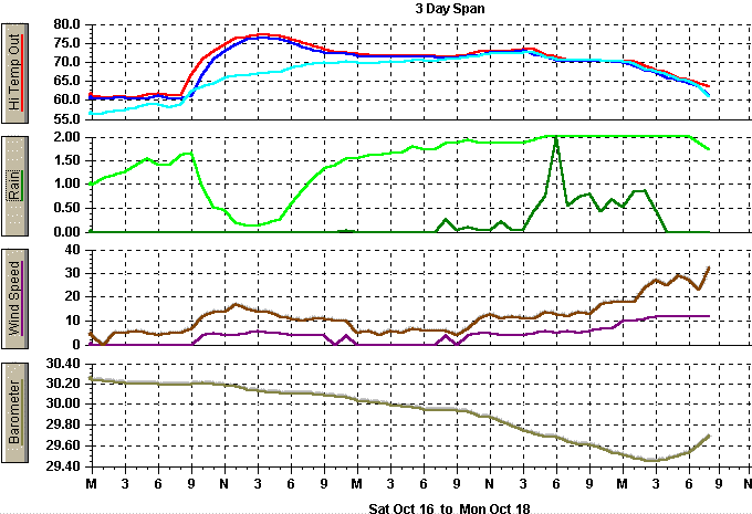
Hurricane Irene sent a few showers and dense fog on its extreme northern edges
as is moved northeast off the FL coast Saturday night (10/16). Clouds and
rainbands moved rapidly north from the weakened storm Sunday with rain beginning
in earnest during early morning. Showers and fog presisted throughout the
day and winds were generally light. By mid and late afternoon, rains became
moderate to heavy with 2.00" recorded between 5 and 6 PM EDT. Flooding followed
for most all secondary roads at this site with major highways affected later
in the evening Sunday (10/17) into early Monday (10/18).
Storm rainfall total was 10.07" with
7.82" falling on Sunday (10/17). This daily rainfall rate established
a NEW DAILY PRECIP RECORD (10/17) and established the ALLTIME DAILY PRECIP RECORD
at this site since records began on 7/1/76.
Rainfall across SE Virginia varied from 1-3" well inland (to the west and to the
north) to over 10" in a swath
from Norfolk south across Eastern Portsmouth and into Western Virginia Beach and
south through central Chesapeake. The usual, expected flash flood warnings were
verified as extensive flooding of flood prone areas was observed in many areas
where excessive rainfall fell. Waters ranging from 1/2 foot to up to 4 feet of
water covered many roadways in the areas where heaviest rainfall amounts were recorded.
Rainfalls between 3 and 6" were reported over the Peninsula area or northside
Hampton Roads.
Winds from the Hurricane locally were not noteworthy until Monday morning (10/18) when
gusts into the 30 MPH and 40 MPH range were observed. Highest sustained and
gusty winds remained to the east of the storm's center as it paralleled
the Southeast US coast but remained offshore late Sunday (10/17).
The lowest barometric pressure recorded here was 29.456" early Monday morning
(10/18) as the storm pulled E and NE of Cape Hatteras on its way to sea and well
to the SE of this site.
The storm moved across the western tip of Cuba, north-northeast crossing central
South Florida, then NNE paralleling the Florida coast, then NE offshore and
paralleling the South Carolina and North Carolina coasts. The storm was
barely minimum hurricane strength during that trekk until it moved well ENE of
Cape Hatteras and ESE of Virginia Beach, Virginia when it deepened with winds sustained
to 105 MPH and higher gusts to near 130 MPH. This sent some stronger backside
storm winds gusting to the 40 MPH range locally Monday morning.
A tornado touched down south of here in NE NC in the Weeksville community.
Here's a report from NWS Wakefield, VA:
During Sunday evening (10/18) a tornado warning was posted for portions of Southern
Chesapeake.
Station daily rainfall amounts associated with Irene:
0630 PM    WEEKSVILLE                NC   TORNADO
10/17/99   PASQUOTANK                     *** 1 INJ ***

A STRONG F1...BORDERLINE  F2 TORNADO TOUCHED DOWN 1  MILE NORTH OF THE TOWN OF
WEEKSVILLE NEAR THE INTER SECTION OF TOXEY ROAD AND  N.C. ROUTE 34. THE TORNADO
MOVED DUE NORTH FOR ABOUT 1/5 MILE WITH A PATH WIDTH   OF 50 YARDS. 2 TRAILERS WERE
TOTALLY DESTROYED. 1 TRAILER  WAS FLIPPED OVER AND ANOTHER  SUSTAINED SOME DAMAGE. A
MODULAR HOME SUSTAINED  SIGNIFICANT DAMAGE WITH SEVERAL VEHICLES IN THE FRONT
YARD TURNED 90 DEGREES. ONE  VEHICLE WAS THROWN UP INTO A TREE AND WRAPPED PARTIALLY
AROUND THE TREE. A  CINDERBLOCK BUILDING  SUSTAINED A WALL FAILURE AND
A PARTIAL COLLAPSE OF THE  ROOF. CLAY ROOFING TILES FROM  THIS BUILDING WERE THROWN
100 YARDS FROM THE BUILDING.   SEVERAL OTHER STRUCTURES  SUSTAINED MINOR DAMAGE.
2 TREES...A PINE AND WILLOW  TREE WERE COMPLETELY  STRIPPED OF ALL BRANCHES.
IN ADDITION A REFRIGERATOR  WAS CARRIED THE ENTIRE PATH  LENGTH OF THE TORNADO AND
DEPOSITED IN THE FRONT YARD  OF THE MODULAR HOME.
Sunday, 10/17 - 7.82"
Monday, 10/18 - 2.21"
Total - 10.07"
Note: File extends beyond right margin on smaller screens.

-----------------------------------------------------------------------------------------------------------------------------------
                         TH     Temp   Wind     Hi      Low    Hum      Dew     Wind                                    Temp   Hum     Arc
 Date           Time    Index   Out    Chill    Temp    Temp   Out      Pt.     Speed   Hi      Dir        Rain Barom   In     In      Per
-----------------------------------------------------------------------------------------------------------------------------------
10/16/99	11:00p	74.6	72.3	72.3	72.4	72.3	93	70.2	4.0	10.0	NNE	   0.04	30.073	79.0	56	60
10/16/99        11:59p  74.6    72.1    72.1    72.3    71.8    93      70.0    0.0     5.0     NE         0.00 30.041  78.6    56      60

10/17/99	 1:00a	74.8	71.5	71.5	71.9	71.4	94	69.7	0.0	6.0	NE	   0.00	30.029	78.2	56	60
10/17/99	 2:00a	74.8	71.6	71.6	71.7	71.4	94	69.8	0.0	4.0	NE	   0.00	30.021	78.2	55	60
10/17/99	 3:00a	75.0	71.6	71.6	71.7	71.5	95	70.1	0.0	6.0	NE	   0.00	29.995	77.9	57	60
10/17/99	 4:00a	75.0	71.5	71.5	71.6	71.3	95	70.0	0.0	5.0	NE	   0.00	29.985	77.3	57	60
10/17/99	 5:00a	75.4	71.5	71.5	71.6	71.4	97	70.6	0.0	7.0	NNE	   0.00	29.973	77.0	58	60
10/17/99	 6:00a	75.2	71.6	71.6	71.6	71.5	96	70.4	0.0	6.0	NNE	   0.00	29.956	76.7	58	60
10/17/99	 7:00a	74.2	71.4	71.4	71.6	71.3	96	70.2	0.0	6.0	NNE	   0.00	29.947	76.5	58	60
10/17/99	 8:00a	74.6	71.3	71.3	71.4	71.2	98	70.7	4.0	6.0	NE	   0.28	29.940	76.5	57	60
10/17/99	 9:00a	75.6	71.5	71.5	71.7	71.2	98	70.9	0.0	4.0	NE	   0.05	29.946	78.8	56	60
10/17/99	10:00a	75.8	71.7	71.7	71.9	71.6	99	71.4	4.0	7.0	NNE	   0.12	29.927	79.6	56	60
10/17/99	11:00a	75.6	72.3	72.3	72.7	71.8	98	71.7	5.0	11.0	NE	   0.04	29.894	83.3	54	60
10/17/99	12:00p	76.6	72.8	--	72.9	72.6	98	72.2	5.0	13.0	NE	   0.05	29.883	81.4	55	60
10/17/99	 1:00p	76.6	72.7	72.7	72.9	72.6	98	72.1	4.0	11.0	NNE	   0.22	29.841	81.6	55	60
10/17/99	 2:00p	76.6	72.9	72.9	73.2	72.6	98	72.3	4.0	12.0	NE	   0.04	29.796	81.4	56	60
10/17/99	 3:00p	76.6	73.2	73.2	73.3	73.0	98	72.6	4.0	11.0	NE	   0.08	29.752	81.2	56	60
10/17/99	 4:00p	76.8	72.7	72.7	73.3	71.9	99	72.4	5.0	11.0	NNE	   0.47	29.723	80.9	56	60
10/17/99	 5:00p	76.0	71.5	71.5	71.9	71.3	100	71.5	6.0	14.0	N	   0.75	29.692	81.6	56	60
10/17/99	 6:00p	75.0	70.9	70.9	71.3	70.6	100	70.9	5.0	13.0	N	   2.00	29.686	81.7	56	60
10/17/99	 7:00p	74.0	70.4	70.4	70.6	70.3	100	70.4	6.0	12.0	N	   0.55	29.649	79.8	59	60
10/17/99	 8:00p	74.0	70.4	--	70.6	70.3	100	70.4	5.0	14.0	NNE	   0.73	29.612	78.3	61	60
10/17/99	 9:00p	75.0	70.6	70.6	70.6	70.5	100	70.6	6.0	13.0	NNE	   0.80	29.611	78.9	59	60
10/17/99	10:00p	74.0	70.4	70.4	70.6	70.2	100	70.4	7.0	17.0	NNE	   0.44	29.583	79.3	61	60
10/17/99	11:00p	74.0	70.2	--	70.3	70.1	100	70.2	7.0	18.0	N	   0.68	29.538	78.0	62	60
10/17/99        11:59p  74.0    70.1    68.9    70.2    70.0    100     70.1    10.0    18.0    NNE        0.52 29.514  78.3    61      60

10/18/99	 1:00a	74.0	69.6	68.4	70.1	69.1	100	69.6	10.0	18.0	N	   0.84	29.487	77.6	63	60
10/18/99	 2:00a	70.0	68.3	66.2	69.1	67.9	100	68.3	11.0	24.0	N	   0.87	29.467	77.0	63	60
10/18/99	 3:00a	67.7	67.7	64.6	68.0	67.3	100	67.7	12.0	27.0	N	   0.47	29.456	76.6	64	60
10/18/99	 4:00a	66.8	66.8	63.6	67.4	66.0	100	66.8	12.0	25.0	N	   0.03	29.470	76.2	64	60
10/18/99	 5:00a	65.5	65.5	62.2	66.0	65.3	100	65.5	12.0	29.0	N	   0.00	29.504	75.8	64	60
10/18/99	 6:00a	65.0	65.0	--	65.4	64.6	100	65.0	12.0	27.0	N	   0.00	29.543	76.4	62	60
10/18/99	 7:00a	64.2	64.2	60.7	64.6	63.5	98	63.6	7.0	18.0	N	   0.00	29.610	80.0	59	60
-----------------------------------------------------------------------------------------------------------------------------------
                         TH     Temp   Wind     Hi      Low    Hum      Dew     Wind                                    Temp   Hum     Arc
 Date           Time    Index   Out    Chill    Temp    Temp   Out      Pt.     Speed   Hi      Dir        Rain Barom   In     In      Per
-----------------------------------------------------------------------------------------------------------------------------------
RAINFALL TOTALS RECEIVED SO FAR FROM HURRICANE IRENE.
LOCATION AMOUNT (INCHES)
CHESAPEAKE (GREAT BRIDGE) 12.00
PORTSMOUTH 10.02
NORFOLK AIRPORT (ORF) 7.34
COURTLAND VA 7.10
HAMPTON 6.90
ELIZABETH CITY NC 4.92
JAMES CITY COUNTY 4.02
OCEAN CITY MD 3.49
WALLOPS ISLAND VA 3.27
NWS WAKEFIELD 3.86
YORKTOWN 3.29
EMPORIA VA 2.85
SALISBURY MD 2.49
ROANOKE RAPIDS NC 2.33
PETERSBURG 1.52
RICHMOND AIRPORT (RIC) .81